


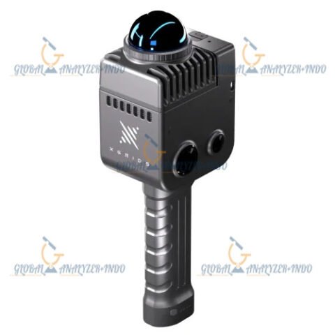
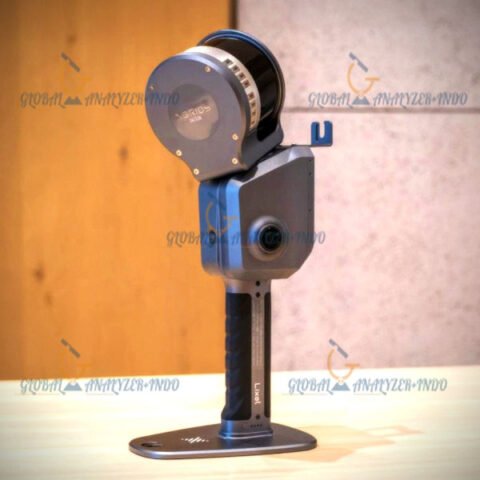
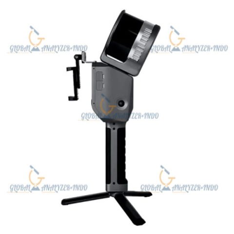
Satlab Cygnus Handheld SLAM LiDAR Scanner
Introduction to the Satlab Cygnus
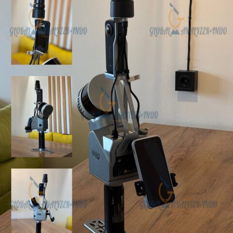
The Satlab Cygnus Handheld SLAM LiDAR Scanner is a state-of-the-art device engineered for fast, precise, and portable 3D scanning. As surveying and mapping technologies advance, professionals require compact solutions that combine mobility with high-quality data capture. Consequently, the Cygnus provides an optimal balance between speed, accuracy, and ease of use.
Moreover, the handheld design allows operators to scan complex environments where traditional LiDAR systems may be impractical. Therefore, it is ideal for indoor mapping, industrial inspections, and infrastructure documentation.
Key Features of the Satlab Cygnus
Handheld Portability for Flexible Use
The Cygnus is lightweight and ergonomically designed. Because of its compact size, users can carry and operate it comfortably for extended periods. In addition, the handheld design enables access to tight spaces, staircases, and complex layouts that are difficult to scan with stationary devices.
Advanced SLAM Technology
Equipped with Simultaneous Localization and Mapping (SLAM), the Cygnus can generate accurate point clouds without relying on GNSS signals. As a result, it performs well in indoor environments, urban canyons, or underground spaces where GPS signals are weak or unavailable.
High-Resolution LiDAR Scanning
The device provides high-density 3D point cloud data, capturing fine details in real time. Consequently, it is suitable for precise measurements, 3D modeling, and digital twin applications.
Real-Time Data Visualization
While scanning, users can monitor data in real time, ensuring complete coverage of the environment. This feature minimizes the need for rescanning and increases workflow efficiency.
Design and Usability
Ergonomic and Intuitive Interface
The Cygnus features a user-friendly interface that simplifies operation. Therefore, even operators with minimal training can achieve professional-quality results.
Rapid Deployment
Unlike traditional scanning systems that require extensive setup, the Cygnus can be powered on and ready to scan within minutes. As a result, project teams save significant time on site.
Applications of the Satlab Cygnus
Surveying and Mapping
The handheld SLAM LiDAR scanner is ideal for topographic surveys, interior mapping, and as-built documentation. Moreover, it provides accurate data for civil engineering, construction planning, and architectural projects.
Construction and Infrastructure
Construction professionals use the Cygnus to verify project progress, inspect structures, and generate 3D models for quality assurance and project management.
Industrial Inspection
The scanner is suitable for equipment layout audits, facility inspections, and maintenance planning. In addition, its portability allows teams to inspect confined or hazardous areas safely.
Digital Twin and BIM
By generating high-fidelity point clouds, the Cygnus supports digital twin creation and BIM workflows. Consequently, organizations can optimize asset management, monitoring, and operational planning.
Advantages of Using the Satlab Cygnus
Enhanced Productivity
The combination of SLAM technology and handheld portability reduces scanning time, allowing teams to complete projects faster than conventional LiDAR setups.
Reliable Performance in Challenging Environments
Whether scanning indoors, underground, or in dense urban areas, the Cygnus maintains accurate tracking and high-quality data capture.
Cost-Effective 3D Scanning Solution
By eliminating the need for bulky setups and external GNSS equipment, the Cygnus provides a cost-efficient scanning solution without compromising performance.
Data Quality and Output
Accurate Point Cloud Generation
The scanner produces high-resolution point clouds suitable for CAD, BIM, GIS, and visualization software. As a result, professionals can trust the data for critical decision-making.
Multiple Export Options
Captured data can be exported in industry-standard formats, ensuring seamless integration with existing workflows and software platforms.
Specifications :
Applications
Mining
Electricity
Utilities
Range
120m
Laser Class
Class 1, Eye Safe
FOV
360 × 285°
Accuracy
0.5-2 cm
Points/s
320,000
Processing
Real-time processing
Display
Real-time preview using mobile terminal
Carrier
Handheld / Backpack / UAV
Scanner Weight
1.5 kg, 227×98×98 mm
Data Logger Weight
0.8 kg, 158×70×145 mm
Channels
16
Battery Life
4 hrs
Ingress Protection
IP65
Internal Storage
512 GB , Extendable to 1TB by TF card
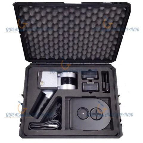
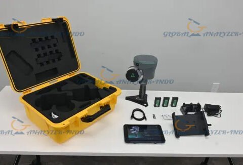
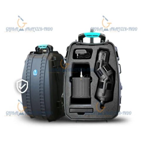
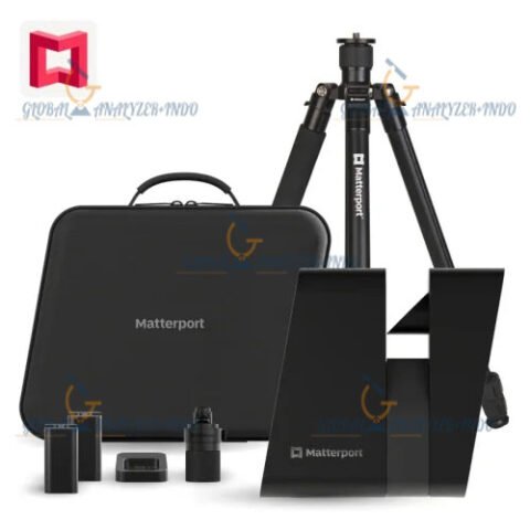
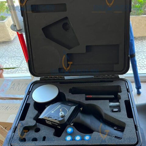
INCLUDED :
Mainframe (Cygnus)
Data-logger (Supports 2 batteries and hot-swap)
Handle (12 cm)
Shoulder strap (80-160 cm)
Main cable (111 cm)
Memory Card (128 GB)
Battery (14.4v, 6800mAh)
Battery Charger (14-16.8 V)
Host Machine Charger (19 V)
Memory Card Storage Box (Supports 8 x SD cards & 16 TF cards)
USB Flash Disk (64 GB)
Mobile Phone Support (Max 9.3 cm)
LED Flashlight (Max 800 lm)
Charge Cable for LED Light (30.5 cm)
Safe Transporting Box (40 * 30 * 15 cm)
There are no reviews yet.