


Gexcel Heron Lite Color 3D Mapping System
The Gexcel Heron Lite Color 3D Mapping System is an innovative solution for high-precision three-dimensional mapping and spatial data acquisition. Designed for professionals in surveying, construction, and geospatial analysis, the system captures accurate 3D models of physical environments with rich color detail. Its portable design and user-friendly interface make it suitable for fieldwork where mobility and speed are essential.
Overview of Gexcel Heron Lite Color 3D Mapping System
The Gexcel Heron Lite combines advanced LiDAR technology with high-resolution color imaging to deliver comprehensive spatial data. The system enables users to scan environments quickly while preserving detailed geometric and visual information. Its compact form factor allows for easy deployment in indoor and outdoor sites, making it ideal for both small-scale and large-scale mapping tasks.
Purpose and Functionality
The primary function of the Gexcel Heron Lite is to produce accurate and visually detailed 3D models that support surveying, engineering, and digital reconstruction projects. The system allows users to capture terrain features, building structures, and complex surfaces without manual measurement, reducing errors and improving workflow efficiency.
Core Technology and Performance
The Gexcel Heron Lite integrates lightweight LiDAR sensors with color imaging technology, providing a balanced combination of precision and visual fidelity. The system captures millions of points per second, ensuring dense and accurate point clouds that reflect the real-world geometry of scanned objects and environments.
High-Resolution 3D Mapping
The Heron Lite generates detailed point clouds enriched with color information, which allows users to distinguish surface textures and materials. This capability facilitates better interpretation of scanned areas and enhances the quality of digital models for reporting and visualization purposes.
Fast and Efficient Data Capture
The system scans large areas quickly, reducing field time while maintaining high accuracy. Its efficient scanning workflow allows professionals to complete multiple survey tasks in a single session, improving productivity and minimizing the need for repeat scans.
Applications of Gexcel Heron Lite Color 3D Mapping System
The Gexcel Heron Lite supports a wide range of professional applications where precise 3D data is required. Its versatility enables deployment in varied environments and project types.
Surveying and Geospatial Analysis
Surveyors use the Heron Lite to map terrains, infrastructure, and construction sites accurately. The system provides reliable spatial data for topographic surveys, volume measurements, and site planning.
Construction and Building Documentation
Engineers and architects utilize the Heron Lite to capture detailed models of buildings and construction sites. Accurate 3D scans support design verification, progress monitoring, and quality assurance.
Cultural Heritage and Environmental Mapping
The system is also suitable for documenting historical sites and natural landscapes. Its color-enhanced 3D models help preserve visual and structural information for analysis, restoration, and educational purposes.
Design and Usability
The Gexcel Heron Lite features a lightweight and ergonomic design that facilitates portability in diverse field conditions. Its intuitive software interface allows users to control scanning parameters easily and process data efficiently, even in complex environments.
Portable and Field-Ready
The compact form factor allows professionals to carry and deploy the system without extensive setup. This mobility is particularly useful for remote locations or sites with limited access, where conventional scanning systems may be cumbersome.
Benefits of Using Gexcel Heron Lite Color 3D Mapping System
The Heron Lite enables professionals to capture highly accurate and visually detailed 3D models quickly. It reduces the need for manual measurements, minimizes human error, and enhances data reliability for planning, analysis, and documentation purposes. Its portability and speed make it a practical choice for field professionals seeking efficiency without sacrificing quality.
Specifications :
Data Storage
Max. data storage CInternal + External in Gb)
256
Data storage type ( 120 characters )
USB 3.1 Gen 1
Power Supply
Battery type (120 characters)
Li-ion 6700 mAh / 80.4 Wh / 12 V
Operating time on single battery (hr)
1.5
More information
Main applications
Digital archive – Floor plans generation for asset management – Construction progress monitoring – Logistic/traffic management – Dilapidation monitoring – Scan to BIM – Contours and profiles – 3D virtual experience – As-built generation
Training facilities
Yes
Distinguishable features
Mountable on car, bike, boat, quad, trolley – Usable in every light conditions – Initialization procedure not required – Loop closure not mandatory – SLAM patented algorithms – Control points and control scans as constraints – Advanced data analysis – Compatibility with AutoCAD, ReCap, EdgeWise, Verity, Cintoo Cloud.
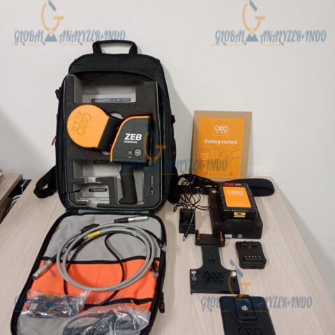
INCLUDED :
6M Telescopic Pole
Tilt Adapter
2M Telescopic Pole
Centering Tip
Ring Led Light
Car Mount
Lightweight Backpack
Shoulder Trap
Extra Battery
Rugged Bacpack
Why Choose Gexcel Heron Lite for 3D Mapping
The Gexcel Heron Lite Color 3D Mapping System combines precision, speed, and portability in a single solution. It is ideal for professionals in surveying, construction, geospatial analysis, and heritage documentation who require accurate and detailed 3D data. By delivering reliable point clouds enriched with color information, the Heron Lite supports informed decision-making, enhanced visualization, and improved project efficiency.


There are no reviews yet.