


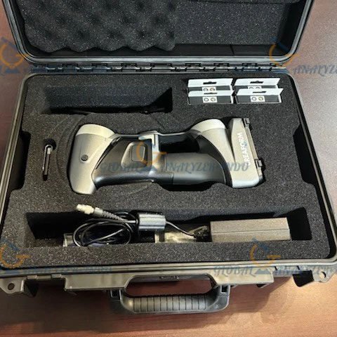
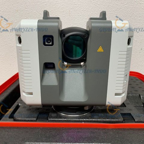
Xgrids Lixel L2 Pro Handheld SLAM LiDAR 3D Scanner (16CH / 120m)
Overview of the Xgrids Lixel L2 Pro
The Xgrids Lixel L2 Pro Handheld SLAM LiDAR 3D Scanner is a compact and high-performance mobile scanning solution designed for fast and accurate 3D data capture. Equipped with a 16-channel LiDAR sensor and a 120-meter scanning range, this device enables professionals to efficiently map complex indoor and outdoor environments without the need for GNSS or external positioning systems.
By combining SLAM (Simultaneous Localization and Mapping) technology with a portable handheld design, the Lixel L2 Pro delivers reliable point cloud data in real time, making it ideal for surveying, construction, engineering, and digital twin applications.
Key Features of the Lixel L2 Pro
16-Channel LiDAR Sensor for High Accuracy
The Lixel L2 Pro uses a 16-channel LiDAR system that provides dense and detailed point cloud data. This configuration ensures balanced performance between accuracy, speed, and data efficiency, even in complex environments.
Long Scanning Range up to 120 Meters
With a maximum scanning distance of 120 meters, the device can capture large spaces quickly, reducing the need for repeated passes and improving workflow efficiency.
Advanced SLAM Technology
The built-in SLAM algorithm allows the scanner to operate without GNSS signals, making it suitable for indoor spaces, underground areas, and urban environments where satellite signals are unreliable.
Design and Portability
Lightweight Handheld Form Factor
The compact and ergonomic design of the Lixel L2 Pro allows users to operate it comfortably for extended periods. Its handheld form factor makes it easy to move through tight spaces, staircases, and complex layouts.
Rapid Deployment and Ease of Use
The device is designed for quick setup and operation. Users can start scanning within minutes, reducing preparation time and increasing productivity on site.
Data Quality and Output
High-Density Point Cloud Generation
The Lixel L2 Pro produces high-resolution point clouds suitable for professional analysis, modeling, and visualization. The data quality supports precise measurements and detailed spatial understanding.
Multi-Format Data Export
Captured data can be exported in common industry formats, enabling seamless integration with CAD, BIM, GIS, and 3D modeling software.
Applications of the Xgrids Lixel L2 Pro
Surveying and Mapping
The scanner is well suited for topographic surveys, indoor mapping, and as-built documentation, allowing surveyors to capture accurate spatial data efficiently.
Construction and Engineering
Construction professionals can use the Lixel L2 Pro to monitor progress, verify structures, and create accurate as-built models for project management.
Facility Management and Digital Twins
The device supports the creation of digital twins for buildings and infrastructure, helping facility managers optimize maintenance, planning, and asset management.
Public Safety and Inspection
Its ability to rapidly scan environments makes it useful for emergency response planning, inspections, and safety assessments.
Advantages of Using the Lixel L2 Pro
Increased Productivity
Fast data capture and real-time SLAM processing significantly reduce fieldwork time compared to traditional scanning methods.
Cost-Effective 3D Scanning Solution
By combining portability, performance, and accuracy, the Lixel L2 Pro offers a cost-efficient alternative to larger and more complex LiDAR systems.
Reliable Performance in Challenging Environments
The scanner performs well in areas with limited lighting, narrow corridors, and GNSS-denied locations.
Specifications :
Model
16/120
Working Range
0.5m -120m
Laser Class
Class 1 / 905 nm
Laser FOV
360 x 270 degrees
Scan Speed
320k points/s
Processing Mode
Real-time/Post-processing
Operating Temperature
-20-50 C
Storage Capacity
1TB SSD
Operating Time
90 min
Protection Level
IP54
Handheld Weight
1.7 kg
Dimensions
180×130×400mm
Visual-Aided Positioning
Supported
Real-Time Colored Point Cloud
Supported
5G Real-Time Transmission
Supported
RTK Fusion
Supported
Resume Scanning from Breakpoint
Supported
Point Cloud Format
.las
Relative Accuracy
+-1.2 cm
Absolute Accuracy
3 cm
Repeat Accuracy
2 cm
Number of Cameras
3
Power Consumption
<30W
Power Supply
Fast-lock battery/External power
Battery Capacity
46.8wh
INCLUDED :
RTK Standard Kit
Survey Grade RTK Kit
Mobile Phone Mount
Extension Pole Kit
Backpack Module
GCP Collection Plate
Handheld Battery System


There are no reviews yet.